
J&K Land Records and JK Bhunaksha 2026: Check Jammu Kashmir Land Map, Jamabandi JK and Massavi Map
Check and download Jammu & Kashmir Jamabandi online. View interactive Masavi / Latha Map plot maps using your Khasra / Survey Number. Track Intiqal (Mutation) status and obtain digitally signed revenue records in हिन्दी / اردو (Hindi / Urdu) and English.
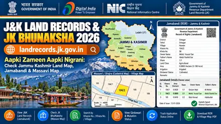
landrecords.jk.gov.in) portal overview for Jamabandi, Masavi / Latha Map, and Intiqal.
जम्मू और कश्मीर लैंड रिकॉर्ड्स (जमाबंदी, गिरदावरी और मसावी नक्शा) ऑनलाइन देखें
जम्मू और कश्मीर में अपनी जमीन की जमाबंदी, खसरा गिरदावरी, इंतकाल और मसावी नक्शा (Masavi Map) ऑनलाइन देखने के लिए आधिकारिक पोर्टल landrecords.jk.gov.in (Aapki Zameen Aapki Nigrani) पर जाएं। अपना जिला, तहसील और गांव चुनकर खसरा या खेवट नंबर से रिकॉर्ड की जांच करें।
जम्मू और कश्मीर: राजस्व पोर्टल एवं भूमि अभिलेख संक्षिप्त विवरण
| विवरण / श्रेणी | आधिकारिक जानकारी |
|---|---|
| राज्य / केंद्र शासित प्रदेश | जम्मू और कश्मीर (Jammu & Kashmir) |
| आधिकारिक पोर्टल का नाम | आपकी ज़मीन आपकी निगरानी (Aapki Zameen Aapki Nigrani) |
| प्रबंधक राजस्व विभाग | Financial Commissioner (Revenue), Jammu & Kashmir |
| अधिकार अभिलेख (ROR दस्तावेज) | Jamabandi |
| भू-नक्शा / सजरा मैप | Masavi / Latha Map |
| खसरा / प्लॉट / सर्वे नंबर | Khasra / Survey Number |
| खाता / खतौनी / खेवट संख्या | Khewat & Khatauni Number |
| दाखिल-खारिज / नामांतरण प्रक्रिया | Intiqal (Mutation) |
| प्रशासनिक क्रम (Location Path) | District → Tehsil → Niabat / Patwar Halqa → Village (Estate) |
जम्मू और कश्मीर: आधिकारिक सरकारी पोर्टल लिंक्स
| पोर्टल का नाम | प्रमुख सेवा | आधिकारिक वेबसाइट |
|---|---|---|
| J&K Land Records Portal (AZAN) | Jamabandi, Girdawari & Masavi | पोर्टल खोलें ↗ |
J&K मसावी नक्शा (Masavi Map) और जमाबंदी देखने की प्रक्रिया
- आधिकारिक पोर्टल landrecords.jk.gov.in खोलें और 'Search Land Records' पर क्लिक करें।
- अपना जिला (District), तहसील (Tehsil) और गांव (Village) चुनें।
- Masavi (नक्शा), Jamabandi, Girdawari या Mutation विकल्प चुनें।
- खसरा नंबर, खेवट नंबर या मालिक का नाम दर्ज कर डिजिटल स्कैन कॉपी देखें।
जम्मू-कश्मीर ऑनलाइन जमाबंदी और इंतकाल जांचने की विधि
- landrecords.jk.gov.in पर 'Digital Jamabandi' चुनें।
- खेवट नंबर या खसरा नंबर दर्ज करके मालिक का नाम और रकबा (कनाल-मरला में) सत्यापित करें।
जम्मू और कश्मीर: अक्सर पूछे जाने वाले प्रश्न (FAQs)
1. जम्मू-कश्मीर में जमीन का रिकॉर्ड देखने का सरकारी पोर्टल कौन सा है?
'आपकी ज़मीन आपकी निगरानी' (landrecords.jk.gov.in) जम्मू-कश्मीर राजस्व विभाग का आधिकारिक पोर्टल है।
2. जमीन का नक्शा (भू-नक्शा) ऑनलाइन देखने के लिए किन विवरणों की आवश्यकता होती है?
आपको अपना जिला, तहसील/अंचल और गांव चुनने के बाद जमीन का Khasra / Survey Number / Khewat & Khatauni Number दर्ज करना होता है।
3. क्या बिना डिजिटल हस्ताक्षर वाली ऑनलाइन प्रति बैंक लोन या कोर्ट में मान्य है?
साधारण ऑनलाइन प्रिंटआउट केवल जानकारी के लिए है। बैंक लोन (KCC), रजिस्ट्री या कानूनी कार्य के लिए QR कोड वाली डिजिटल हस्ताक्षरित (Digitally Signed) नकल या जन सेवा केंद्र (CSC) से प्रमाणित प्रति प्राप्त करें। Citizens can view scanned original registers online and apply for revenue extracts (Fard) via the J&K Revenue online services portal.
Jammu & Kashmir (JK) official ROR, Bhu Naksha, citizen login and IGRS EC portal linkup
Each government task in Jammu & Kashmir uses a specific portal module. Follow the exact menu path listed on each card below so you go straight to the right screen:
Aapki Zameen Aapki Nigrani Jamabandi Lookup Portal
Exact Menu Path: Home > View Jamabandi > Select District, Tehsil, Niabat / Patwar Halqa, Village (Estate) > Enter Khasra / Survey Number or Khewat & Khatauni Number
Check live landowner names, co-sharer shares, land class, and bank loan remarks by Khasra / Survey Number or Khewat & Khatauni Number.
Jammu & Kashmir Masavi / Latha Map Cadastral Map Portal
Exact Menu Path: Select District, Tehsil, Niabat / Patwar Halqa, Village (Estate) > Click Khasra / Survey Number on Map > Download Map Report PDF
View the scaled village plot map (Masavi / Latha Map), check 4-side boundary dimensions, road access, and neighboring plot numbers.
Jammu & Kashmir Citizen Login (Intiqal, Tax & Signed QR Copy)
Login & Path: Citizen Mobile OTP Login on landrecords.jk.gov.in
Download legally valid Digitally Signed QR copies, pay annual land tax online, and file or track Intiqal cases.
Jammu & Kashmir Registration, Stamp Duty & Encumbrance (EC) Portal
Exact Menu Path: Citizen Services > Verify Encumbrance Certificate (EC), Circle Rate & Registered Deed
Verify registered Sale Deeds (Index-II), 12 to 30 year Encumbrance Certificates (EC), government circle rates, and prohibited land lists.
Jammu & Kashmir (जम्मू और कश्मीर) direct service launcher
Select your land record service below to open the official Aapki Zameen Aapki Nigrani (LRIS J&K) portal:
1. View plot map (Masavi / Latha Map)
Check plot shape, boundary lengths, and neighboring parcels with your Khasra / Survey Number.
2. Check ownership (Jamabandi)
Check recorded owner names, share extent, and crop details with your Khewat & Khatauni Number.
3. Track Intiqal (Mutation)
Check mutation status after deed registration or family inheritance.
4. Certified QR copy
Download a digitally signed ROR or map PDF for bank loans and court use.
Jammu & Kashmir (जम्मू और कश्मीर) citizen land utility suite (7 interactive calculators and verification tools)
Select any tool below to convert land units, measure 4-sided irregular plots, split joint family shares, calculate stamp duty, convert map scales, check required documents, or verify property records for Aapki Zameen Aapki Nigrani (LRIS J&K):
Enter your plot area from Aapki Zameen Aapki Nigrani (LRIS J&K) to convert it across standard and regional measurement units. Click any result to copy.
Enter the North, South, East, and West boundary lengths of your plot from the Masavi / Latha Map to calculate exact area.
Enter the property market or circle rate value to estimate stamp duty, female buyer concession savings, and registration fees.
Measure any plot side on your printed Masavi / Latha Map with a ruler and convert that paper length into actual ground distance in Feet, Meters, and Kadi.
Choose the land revenue service you want to apply for to view the required documents, fee, and approval timeline.
Check off each verified item below while reviewing the seller's Jamabandi and Masavi / Latha Map before property registration.
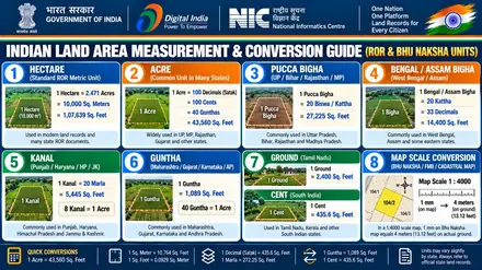
How to check Jammu & Kashmir (जम्मू और कश्मीर) land records and plot map online
Open the official Aapki Zameen Aapki Nigrani (LRIS J&K) portal (official Aapki Zameen Aapki Nigrani (LRIS J&K) (landrecords.jk.gov.in)) managed by the Financial Commissioner (Revenue), Jammu & Kashmir. Select your District, Tehsil, Niabat / Patwar Halqa, Village (Estate) from the menu. Enter your Khasra / Survey Number or Khewat & Khatauni Number to view the Jamabandi and download the Masavi / Latha Map PDF report.
Jammu & Kashmir (जम्मू और कश्मीर) revenue portal fact sheet
| Attribute | Official Jammu & Kashmir Details |
|---|---|
| State or Union Territory | Jammu & Kashmir • जम्मू और कश्मीर (North & Central India) |
| Official Languages | हिन्दी / اردو (Hindi / Urdu) and English |
| Official Portal Name | Aapki Zameen Aapki Nigrani (LRIS J&K) (आपकी ज़मीन आपकी निगरानी (Aapki Zameen Aapki Nigrani)) |
| Managing Authority | Financial Commissioner (Revenue), Jammu & Kashmir |
| Ownership Document (ROR) | Jamabandi |
| Cadastral Plot Map | Masavi / Latha Map |
| Plot or Survey Identifier | Khasra / Survey Number |
| Account or Ledger Identifier | Khewat & Khatauni Number |
| Mutation Process | Intiqal (Mutation) |
| Administrative Hierarchy | District → Tehsil → Niabat / Patwar Halqa → Village (Estate) |
Official Jammu & Kashmir government portals
The Financial Commissioner (Revenue), Jammu & Kashmir runs online portals for land ownership registers, plot boundaries, and revenue case updates. Jammu & Kashmir organizes its digital records under Jamabandi and Masavi / Latha Map. You can also check nearby regional portals for Uttar Pradesh (UP Bhulekh & UP Bhu Naksha) and Madhya Pradesh (MP Bhulekh (WebGIS 2.0)).
| Portal Name | Primary Service | Official Website Link |
|---|---|---|
| J&K Land Records Portal (AZAN) | Jamabandi, Girdawari & Masavi | J&K Land Records Portal (AZAN) (landrecords.jk.gov.in) ↗ |
Details needed to check Jammu & Kashmir land records
Keep these four details ready to check property records or plot maps on Aapki Zameen Aapki Nigrani (LRIS J&K):
- Select your exact location sequence (District → Tehsil → Niabat / Patwar Halqa → Village (Estate)) from the drop-down menus.
- Enter your Khasra / Survey Number to locate the land parcel on the village map and check its dimensions.
- Enter your Khewat & Khatauni Number to view all plots held by one landowner or family in the village.
- Search by the recorded landowner name whenever you want to look up the Khasra / Survey Number or Khewat & Khatauni Number.
How to view and download Jammu & Kashmir Masavi / Latha Map online
The cadastral map shows the physical shape, boundary lengths, and neighboring plots of a land parcel. Follow these five steps in Jammu & Kashmir:
- Open the official Jammu & Kashmir mapping portal (J&K Land Records Portal (AZAN)).
- Select your District → Tehsil → Niabat / Patwar Halqa → Village (Estate) in the location menu to load the village map sheet.
- Enter your Khasra / Survey Number in the search box, or click directly on the land parcel inside the village map.
- Review the owner names, plot area, and land classification displayed in the verification panel.
- Click Map Report or Sketch PDF to save the plot map with its scale and north arrow.
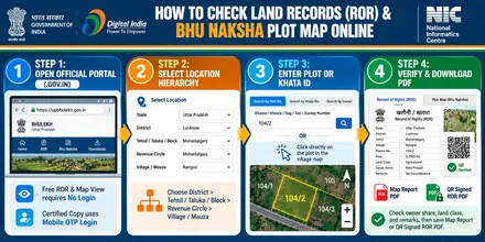
landrecords.jk.gov.in.
How to check Jammu & Kashmir Jamabandi online
The Jamabandi is the main text register of ownership, share extent, crop details, and bank loans. Follow these steps to view it online:
- Open J&K Land Records Portal (AZAN) (https://landrecords.jk.gov.in) in your web browser.
- Select the option to view Jamabandi on the home screen.
- Choose your District → Tehsil → Niabat / Patwar Halqa → Village (Estate) and the current revenue year.
- Select your search method (Khasra / Survey Number, Khewat & Khatauni Number, or Owner Name), enter the value, and submit the captcha code.
- Check each co-owner's share, total land area, and the remarks column, then print or save the PDF copy.
How to read your Jammu & Kashmir Jamabandi and Masavi / Latha Map
Official revenue extracts on Aapki Zameen Aapki Nigrani (LRIS J&K) use five standard columns. Use this table to verify each section before buying land or applying for a loan:
| Document Column | Meaning in Jammu & Kashmir | Buyer Verification Action |
|---|---|---|
| 1. Khewat & Khatauni Number | Unique ledger number assigned to a landowner or joint family holding in the village. | Match the seller's name and parent or spouse name with their Aadhaar card and sale deed. |
| 2. Khasra / Survey Number | Unique parcel number on the village cadastral map (Masavi / Latha Map). | Confirm that the plot number on the Jamabandi matches the parcel on the Masavi / Latha Map. |
| 3. Land Area and Share | Total parcel area and each co-owner's fractional share. | Verify that the sale area stays within the seller's recorded share using the Area Unit Calculator. |
| 4. Land Classification | Category of land: Proprietary (Milkiyat) Land, Kahcharai (Grazing Land), Shamilat Deh, and State Land.. | Confirm that the parcel belongs to a private transferable land category. |
| 5. Remarks and Mutation | Lists Intiqal (Mutation) orders, crop loans (KCC), bank mortgages, and court orders. | Confirm that the remarks column shows a clear title for the parcel. |
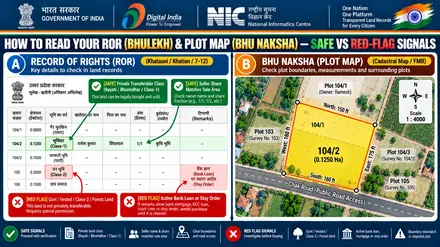
Jammu & Kashmir land record services: fees, time and legal validity
Review the fee structure, processing time, and legal use case for each Jammu & Kashmir revenue document:
| Service Type | Official Fee | Processing Time | Legal Validity and Use Case |
|---|---|---|---|
| Informational Jamabandi View | Free (₹0) | Instant Online | Personal verification of owner name, share, and plot status. |
| Informational Masavi / Latha Map PDF | Free (₹0) | Instant Online | Checking plot boundaries, road access, and neighboring survey numbers. |
| Digitally Signed QR Jamabandi or Map | ₹15 to ₹50 per copy | Instant to 24 Hours | Legally valid for bank loans, KCC, property registration, and courts. Citizens can view scanned original registers online and apply for revenue extracts (Fard) via the J&K Revenue online services portal. |
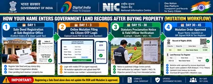
| Intiqal (Mutation) Application | Standard State Tariff | 15 to 45 Working Days | Updates the buyer or legal heir name in the Jamabandi after deed registration or succession. |
Aapki Zameen Aapki Nigrani (LRIS J&K) portal help and quick solutions
Follow these steps to resolve common display or search issues on the official Jammu & Kashmir portal:
1. How to open the plot map report PDF
The Masavi / Latha Map portal opens PDF map reports in a new browser tab. Enable pop-ups in your Chrome settings for https://landrecords.jk.gov.in and click Show Report.
2. How to locate subdivided plot numbers
Plot subdivisions add suffix numbers or letters such as /1, /2, or Min. Search by the Landowner Name or Khewat & Khatauni Number first to view the updated plot number.
3. How to correct a name or area entry
Submit an online record correction request on Aapki Zameen Aapki Nigrani (LRIS J&K) with your registered deed copy, or visit your local J&K Revenue Grievance Portal.
Land classifications and official helpdesk in Jammu & Kashmir
Land classifications in Jammu & Kashmir: Proprietary (Milkiyat) Land, Kahcharai (Grazing Land), Shamilat Deh, and State Land..
Certified copy procedure: Citizens can view scanned original registers online and apply for revenue extracts (Fard) via the J&K Revenue online services portal.
Helpdesk and office support: J&K Revenue Grievance Portal / Tehsil Office.
Jammu & Kashmir (JK) Aapki Zameen Aapki Nigrani (LRIS J&K): citizen login, plot information, online tax (Khajna/Lagan) and e-KYC
Use these five official citizen service modules on Aapki Zameen Aapki Nigrani (LRIS J&K) (landrecords.jk.gov.in) to log in, check plot and Jamabandi details by owner name, pay land revenue tax online, and link Aadhaar:
| Portal Module / Service | How It Works on Aapki Zameen Aapki Nigrani (LRIS J&K) (JK) | Exact Menu Path & Citizen Action |
|---|---|---|
| 1. Free Jamabandi & Plot Info No Login Needed |
Displays live plot area, land classification, co-sharer fractions, and Intiqal (Mutation) history by Khasra / Survey Number, Khewat & Khatauni Number, or Owner Name. | Home > View Jamabandi > Select District, Tehsil, Niabat / Patwar Halqa, Village (Estate) > Enter Khasra / Survey Number or Khewat & Khatauni Number on official Jammu & Kashmir Jamabandi portal (landrecords.jk.gov.in) ↗. |
| 2. Cadastral Plot Map (Masavi / Latha Map) Direct Map Sheet |
Shows the scaled village map (`1:4000`), 4-side boundary lengths, road access, and neighboring plot numbers (Chauhaddi). | Select District, Tehsil, Niabat / Patwar Halqa, Village (Estate) > Click Khasra / Survey Number on Map > Download Map Report PDF on official Jammu & Kashmir Masavi / Latha Map portal (landrecords.jk.gov.in) ↗. |
| 3. Citizen Login, Tax & Intiqal Mobile OTP Login |
Pays annual land revenue tax (Khajna / Lagan / Pauti), downloads digitally signed QR copies (₹15 to ₹50), and tracks Intiqal (Mutation). | Citizen Mobile OTP Login on landrecords.jk.gov.in on official Jammu & Kashmir Citizen Login (landrecords.jk.gov.in) ↗. |
| 4. Sub-Registrar Deed & EC Check IGRS / Stamp Portal |
Verifies registered Sale Deeds (Index-II), 12 to 30 year Encumbrance Certificates (EC), government circle rates, and prohibited land lists. | Citizen Services > Verify Encumbrance Certificate (EC), Circle Rate & Registered Deed on official Jammu & Kashmir IGRS portal (landrecords.jk.gov.in) ↗. |
5. Aadhaar e-KYC & Record CorrectionGrievance & Correction |
Links the landowner's Aadhaar and mobile number with their Khewat & Khatauni Number to prevent fraudulent transfers and correct clerical spelling or area errors. | Submit an online correction request with your registered deed PDF or apply to your local revenue officer (J&K Revenue Grievance Portal). |
Jammu & Kashmir (JK) land classifications, transferability rules and buyer red-flag decoder
Before paying an advance or registering a Sale Deed in Jammu & Kashmir (जम्मू और कश्मीर), check the land classification code on the Jamabandi against this legal verification table:
| Verification Check | Official Jammu & Kashmir Revenue Code & Legal Meaning | What a Buyer or Owner Must Do |
|---|---|---|
| 1. Safe Transferable Land Class | Private Transferable Ownership (Proprietary (Milkiyat) Land) with Clear Remarks Column | Confirm that the seller's name, parent/spouse name, and fractional share match both the Jamabandi and the Sub-Registrar EC. |
| 2. Restricted / Prohibited Land Class (Red Flag) | Government / Khas / Forest / Communal Land or Non-Transferable Leasehold Patta | Do not pay an advance. Government, Vested, Forest, or Class-2/Assigned land cannot be sold without prior statutory Collector permission. |
| 3. Non-Agricultural (NA / Conversion) Check | Agricultural plots require formal land-use conversion (NA / Bastu / CLU / Diversion) before residential or commercial construction. | Verify the official Conversion Order number on the Jamabandi before buying a plotted layout or house site. |
| 4. Un-Subdivided Joint Plot (Min / Bataank / Phodi) | When a plot is sold from a larger joint parcel, the new sub-division (`/1`, `/2`, `Min`) must be drawn on the Masavi / Latha Map. | Insist on an official pre-mutation sketch or boundary demarcation so your exact ground parcel is separated on the village map. |
| 5. Revenue Officer Escalation & Helpdesk | Official Authority: Financial Commissioner (Revenue), Jammu & Kashmir Support & Escalation: J&K Revenue Grievance Portal / Tehsil Office |
File clerical corrections or delayed Intiqal appeals online with your Case Number and registered deed copy. |
Jammu & Kashmir (JK) district-wise Aapki Zameen Aapki Nigrani and Bhu Naksha coverage
Official Aapki Zameen Aapki Nigrani (LRIS J&K) land records, Jamabandi registers, and cadastral village maps cover all revenue districts and local revenue offices across Jammu & Kashmir:
Land record terms used in Jammu & Kashmir
Use these regional definitions to read Jammu & Kashmir revenue documents accurately (see also the All-India Land Terminology Glossary):
Aapki Zameen Aapki Nigrani
Public citizen portal allowing anyone to view scanned and digitized Jamabandi, Girdawari, Mutation, and Masavi maps.
Kanal & Marla
Standard land measurement units in J&K (1 Kanal = 20 Marlas = 5,445 sq. ft.).
Masavi
Cadastral village map sheet drawn to scale during settlement operations.
Frequently asked questions (Jammu & Kashmir (जम्मू और कश्मीर))
1. [हिन्दी / اردو (Hindi / Urdu)] जम्मू-कश्मीर में जमीन का रिकॉर्ड देखने का सरकारी पोर्टल कौन सा है?
'आपकी ज़मीन आपकी निगरानी' (landrecords.jk.gov.in) जम्मू-कश्मीर राजस्व विभाग का आधिकारिक पोर्टल है।
2. Which is the official website to check Jammu & Kashmir land records and plot maps?
The Financial Commissioner (Revenue), Jammu & Kashmir manages the official Aapki Zameen Aapki Nigrani (LRIS J&K) portal at official Aapki Zameen Aapki Nigrani (LRIS J&K) website (landrecords.jk.gov.in).
3. What details are needed to view a plot map (Masavi / Latha Map) in Jammu & Kashmir?
Select your location path (District, Tehsil, Niabat / Patwar Halqa, Village (Estate)) and enter your Khasra / Survey Number. You can also find the plot number by searching with the owner name in the Jamabandi register or clicking the parcel on the village map.
4. How do I get a legally valid copy from Aapki Zameen Aapki Nigrani (LRIS J&K) for bank loans or court use?
Standard online printouts work for personal record verification. Download a digitally signed copy with a QR verification code or obtain a certified extract from your local revenue office or CSC for bank loans, registration, and court filings. Citizens can view scanned original registers online and apply for revenue extracts (Fard) via the J&K Revenue online services portal.
5. How do I update my name in Jammu & Kashmir land records after buying land or inheritance?
Submit a Intiqal (Mutation) application with your registered sale deed or succession certificate and identity proof on the state revenue portal or local Tehsil office. The revenue office updates the Jamabandi after approving the mutation order.