
Access the master All-India Bhulekh & Bhu Naksha Portal to inspect verified Record of Rights (Khatauni, Jamabandi, Satbara, Khatian) and download village Bhu Naksha plot maps across all 36 States and Union Territories.
Bhu Naksha Map Scale Calculator: 1:4000 Cadastral Distance & Area Converter
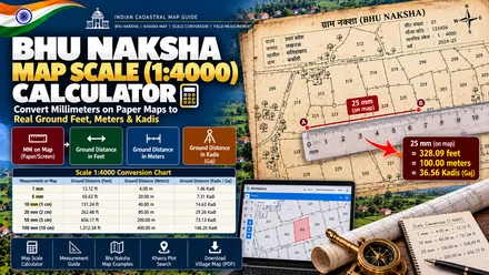
State revenue portals publish cadastral village maps (Bhu Naksha) at a standard 1:4000 scale. On these maps, 1 millimeter equals 4 meters (13.12 feet) on the ground, and 1 centimeter equals 40 meters (131.23 feet). Enter paper ruler measurements in millimeters, centimeters, or inches to find real ground distances in Feet, Meters, Gaj, and Gunter chain links (Kadi).
How to Use the Bhu Naksha Map Scale Calculator
Identify the ratio printed in the sheet legend (standard 1:4000, 1:3960, or 1:2000).
Use a precision engineering ruler or caliper to measure the Khasra boundary line.
Enter the measured number and choose paper unit (mm, cm, or inches).
Read actual ground distance in Feet, Meters, Gaj, Kadi, Gatha, and Karam.
Convert Bhu Naksha Paper Distance to Real Ground Dimensions
Select your cadastral sheet scale ratio and enter your ruler measurement:
The Mathematics of Cadastral Scales: 1:4000 vs 1:3960 Explained
Indian land records bridge two centuries of cartographic engineering:
1:4000 Metric Standard (NIC Bhu Naksha)
Adopted during national computerization under the DILRMP (Digital India Land Records Modernization Programme).
- 1 mm on paper = 4.0 meters on ground (13.123 feet).
- 1 cm on paper = 40.0 meters on ground (131.234 feet).
- 2.5 cm on paper = Exactly 100 meters on ground.
1:3960 Imperial Standard (16 Inches = 1 Mile)
Historical village revenue sheets surveyed by the Survey of India using 66-foot Gunter chains.
- 1 inch on paper = 330 feet (110 yards / 5 Gunter chains).
- 1/10th inch on paper = 33 feet (50 links / Kadis).
- 1 mm on paper = 3.96 meters (12.992 feet).
How to Print Official Bhu Naksha Sheets Without Scale Distortion
A common pitfall encountered by property buyers and advocates is measuring distances on a desktop printout that has been distorted by automatic printer margins:
- Check Designation Paper Size: Village Shajra cadastral sheets are created for large formats (typically A3 or A0 sheets). If printed on standard letter/A4 paper with "Fit to Page", the scale will be drastically compressed.
- Select 100% Actual Size: In Adobe Acrobat Reader or Chrome print settings, set Page Sizing to "Actual Size" (100% scale). Never select "Fit to Printable Area".
- Calibrate Against Graphical Scale Bar: Every authentic Bhu Naksha printout contains a printed graphical scale bar in the legend. Measure the 100-meter segment on the scale bar with your physical ruler to verify exact millimeter calibration before measuring your plot.
Related Land Measurement Tools & Calculators
Select any complementary calculator below to convert units, measure boundaries, or verify ownership records:
Universal Land Unit Converter
Convert between any two Indian land measurement units across states, including Bigha, Biswa, Katha, Dhur, Kanal, Guntha, Cent, Gaj, and Acres.
Land Valuation & Rate Converter
Calculate total land price and compare rates per Sq Ft, per Gaj, per Acre, and per Bigha to evaluate deals and stamp duty benchmarks.
Bigha to Sq Ft Calculator
Calculate state-specific Pucca and Kachha Bigha conversions across Uttar Pradesh, Bihar, MP, Rajasthan, and West Bengal.
Acre to Bigha Calculator
Convert standard 43,560 sq ft acres into regional Bighas for North, East, and Central Indian land records.
Hectare to Bigha Calculator
Convert 4-decimal metric hectares from official Khatauni records into legal Bighas and local sub-units.
Cent to Sq Ft Calculator
Convert 435.6 sq ft Cents and 1,089 sq ft Gunthas for Tamil Nadu, Kerala, Andhra, Telangana, and Karnataka deeds.
Gaj to Sq Ft Calculator
Convert Square Yards (Gaj) to Square Feet for municipal residential layouts and building approval plans.
Dismil to Sq Ft Calculator
Convert Dismil and Decimal units across Bihar, Jharkhand, Odisha, and West Bengal land records.
4-Side Plot Area Calculator
Calculate irregular four-sided plot areas using boundary lengths in Feet, Meters, Kadis, Karams, or Gathas.
Stamp Duty & Registry Calculator
Estimate property registration charges and statutory female buyer concessions across key Indian states.
Family Khata Share Splitter
Divide joint ancestral land holdings among legal heirs and calculate individual acreage and square footage.
Download Official Cadastral Maps from State Portals
Access village geo-referenced plot maps and geo-spatial cadastral sheets on official NIC Bhu Naksha portals:
Frequently Asked Questions on Bhu Naksha Map Scales & Cadastral Survey
1. What does a 1:4000 scale mean on a Bhu Naksha cadastral map?
A 1:4000 scale is the metric cadastral standard used by NIC Bhu Naksha portals across India. It means that 1 unit on paper equals 4,000 units on real ground. Specifically, 1 millimeter (mm) on paper represents exactly 4 meters (13.123 feet) on the ground. 1 centimeter (cm) on paper represents 40 meters (131.23 feet) on the ground.
2. What is the historical 1:3960 Imperial Cadastral Scale?
Prior to metrication, British and early Indian cadastral village sheets were mapped at '16 Inches = 1 Mile', which corresponds mathematically to exactly 1:3960. On a 1:3960 scale map, 1 inch on paper equals exactly 330 feet (5 Gunter Chains or 110 yards) on the ground. 1/10th of an inch equals 33 feet (50 links).
3. Why do Bhu Naksha printouts sometimes measure inaccurate distances with a ruler?
When citizens print official Bhu Naksha PDF sheets from state portals, their web browser or PDF reader often defaults to 'Fit to Printable Area' or 'Shrink Oversized Pages'. This alters the physical zoom ratio by 4% to 8%, destroying cadastral scale accuracy. Always print Bhu Naksha sheets with page scaling set strictly to '100%' or 'Actual Size' on the designated paper size (usually A3 or A0).
4. What are Seh-hadda (तिहद्दा) stones on a cadastral village map?
A Seh-hadda (Seh-hadda / Chanda / चंदा) is a permanent tri-junction stone embedded by the Survey Department at the meeting point of three village boundaries. During ground measurement (Paimaish), Patwaris always anchor their survey chains at a certified Seh-hadda stone to establish unquestionable benchmark coordinates.
5. How many feet are in 100 Kadis (Chain Links)?
A full surveyor chain (Jarib) contains 100 links (Kadis) and measures exactly 66 feet (20.1168 meters). Therefore, each individual link is exactly 0.66 feet or 7.92 inches.