
ഇ-രേഖ കേരളം: കമ്പ്യൂട്ടറൈസ്ഡ് ഭൂരേഖകളും ഡിജിറ്റൽ സർവേ മാപ്പ് പോർട്ടലും DEPARTMENT OF SURVEY & LAND RECORDS, KERALA: E-REKHA & REVENUE PORTAL കമ്പ്യൂട്ടറൈസ്ഡ് തണ്ടപ്പേര്, റവന്യൂ രേഖകൾ, പോക്കുവരവ് மற்றும் എഫ്.എം.ബി സർവേ സ്കെച്ച് • Official Gateway: erekha.kerala.gov.in
कंप्यूटरीकृत Kerala Thandaper Account & Patta (Pattayam) ऑनलाइन प्राप्त करें, Resurvey Number & Block Number (or Old Survey Number) दर्ज करके कैडस्ट्रल FMB Sketch (Field Measurement Book) & Resurvey Map देखें, एवं Pokkuvaravu (Transfer of Registry / Mutation) स्थिति का तुरंत सत्यापन करें। Independent citizen educational directory connecting citizens directly to verified Department of Survey and Land Records & Land Revenue Commissionerate, Kerala revenue servers with open public viewing for informational records (authenticated services and certified copies require citizen login and statutory fees).
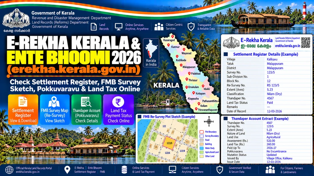
Kerala (കേരളം) में आधिकारिक Thandaper Account & Patta एवं FMB Sketch ऑनलाइन देखने के लिए राज्य के आधिकारिक राजस्व पोर्टल https://erekha.kerala.gov.in पर जाएं। अपने संबंधित District, Taluk और ग्राम का चयन करें। इसके पश्चात Resurvey Number & Block Number अथवा खातेदार के नाम से खोज करके कम्प्यूटरीकृत नकल एवं नक्शा रिपोर्ट तुरंत निःशुल्क डाउनलोड करें।
Kerala भू-अभिलेख एवं कैडस्ट्रल नक्शा: आधिकारिक पोर्टल विवरण एवं मुख्य तथ्य (Portal Overview & Key Details)
अधिकृत पोर्टल विनिर्देश (Official Portal Specifications)| State Jurisdiction | Kerala (കേരളം) |
|---|---|
| Controlling Revenue Authority | Department of Survey and Land Records & Land Revenue Commissionerate, Kerala |
| Official Digital Portal | Official Portal (erekha.kerala.gov.in) ↗ |
| DILRMP Modernization Status | DILRMP 4.0 Active Integration (Computerized RoR | Phased Cadastral Geo-Referencing) |
| Land Identification Metric | Resurvey Number & Block Number (or Old Survey Number) / 14-Digit Bhu-Aadhaar ULPIN |
| Official Portal Citizen Access Fee | Free Informational Viewing (Access conditions vary by service); Certified Copies at Statutory Fee |
| Legal Evidentiary Status | Informational Reference (Certified Copy Governed by BSA 2023 Sec 63, 74-76) |
| Official Citizen Helpline | Village Office / Akshaya e-Center Kerala |
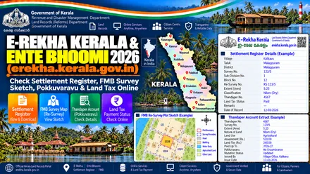
erekha.kerala.gov.in) portal overview for Thandaper Account & Patta, FMB Sketch, and Pokkuvaravu. കേരള ഭൂരേഖകൾ: തണ്ടപ്പേർ (Thandaper), പട്ടയം (Patta), FMB സ്കെച്ച് & ഭൂനികുതി ഓൺലൈൻ ഗൈഡ്
കേരളത്തിൽ ഭൂമിയുടെ സർവ്വേ പ്ലാൻ (FMB Sketch / Resurvey Map), സെറ്റിൽമെന്റ് രജിസ്റ്റർ, തണ്ടപ്പേർ അക്കൗണ്ട് (Thandaper), പോക്കുവരവ് (Mutation) എന്നിവ ഓൺലൈനായി പരിശോധിക്കുന്നതിന് സർവ്വേ വകുപ്പിന്റെ erekha.kerala.gov.in, റവന്യൂ വകുപ്പിന്റെ revenue.kerala.gov.in എന്നീ ഔദ്യോഗിക പോർട്ടലുകൾ ഉപയോഗിക്കുക. ജില്ല, താലൂക്ക്, വില്ലേജ്, ബ്ലോക്ക്, റീസർവ്വേ നമ്പർ എന്നിവ നൽകി ഭൂരേഖകൾ ഡൗൺലോഡ് ചെയ്യാം.
കേരളം: റവന്യൂ പോർട്ടൽ & ഭൂരേഖകളുടെ সংক্ষিপ্ত വിവരണം
| വിവരണം | ഔദ്യോഗിക വിവരം |
|---|---|
| സംസ്ഥാനം / കേന്ദ്രഭരണ പ്രദേശം | കേരളം (Kerala) |
| ഔദ്യോഗിക പോർട്ടൽ പേര് | ഇ-രേഖ & റവന്യൂ ഇ-സർവീസസ് (E-Rekha & Kerala Revenue) |
| നിയന്ത്രണ വകുപ്പ് | Department of Survey and Land Records & Land Revenue Commissionerate, Kerala |
| ഉടമസ്ഥാവകാശ രേഖ (തണ്ടപ്പേർ / പട്ടയം) | Thandaper Account & Patta (Pattayam) |
| ഭൂനকশা (FMB Sketch / Resurvey Map) | FMB Sketch (Field Measurement Book) & Resurvey Map |
| സർവ്വേ / റീസർവ്വേ നമ്പർ | Resurvey Number & Block Number (or Old Survey Number) |
| തണ്ടപ്പേർ നമ്പർ | Thandaper Number |
| പോക്കുവരവ് (Mutation) | Pokkuvaravu (Transfer of Registry / Mutation) |
| ഭരണപരമായ ക്രമം | District → Taluk → Village → Block Number |
കേരളം: ഔദ്യോഗിക സർക്കാർ വെബ്സൈറ്റ് ലിങ്കുകൾ
| പോർട്ടൽ പേര് | പ്രധാന സേവനം | വെബ്സൈറ്റ് ലിങ്ക് |
|---|---|---|
| E-Rekha Kerala (Survey Maps & FMB) | FMB Sketch, Village Maps & Settlement Register | പോർട്ടൽ തുറക്കുക ↗ |
| Kerala Revenue E-Services | Land Tax, Thandaper & Possession Certificate | പോർട്ടൽ തുറക്കുക ↗ |
കേരള FMB സർവ്വേ സ്കെച്ചും റീസർവ്വേ മാപ്പും (E-Rekha) ഡൗൺലോഡ് ചെയ്യുന്ന വിധം
- ഭൂമിയുടെ സർവ്വേ മാപ്പിനായി erekha.kerala.gov.in എന്ന പോർട്ടലിൽ പ്രവേശിക്കുക.
- 'File Search / Map View' തിരഞ്ഞെടുത്ത് നിങ്ങളുടെ ജില്ല (District), താലൂക്ക് (Taluk), വില്ലേജ് (Village) എന്നിവ നൽകുക.
- ബ്ലോക്ക് നമ്പറും (Block No.) റീസർവ്വേ / പഴയ സർവ്വേ നമ്പറും നൽകുക.
- FMB സ്കെച്ച് പ്രിവ്യൂ പരിശോധിച്ച് ഓൺലൈൻ ഫീസ് അടച്ച് സാക്ഷ്യപ്പെടുത്തിയ പകർപ്പ് (Certified PDF) ഡൗൺലോഡ് ചെയ്യുക.
തണ്ടപ്പേർ വിവരങ്ങളും ഭൂനികുതി രസീതും (Land Tax) ഓൺലൈനായി പരിശോധിക്കുന്ന വിധം
- റവന്യൂ വകുപ്പിന്റെ revenue.kerala.gov.in പോർട്ടലിൽ പ്രവേശിക്കുക.
- വില്ലേജും തണ്ടപ്പേർ നമ്പറും (Thandaper No.) അല്ലെങ്കിൽ സർവ്വേ നമ്പറും നൽകി ഭൂമിയുടെ വിശദാംശങ്ങളും നികുതി രസീതും നേടുക.
കേരളം: പതിവായി ചോദിക്കുന്ന ചോദ്യങ്ങൾ (FAQ)
1. കേരളത്തിൽ FMB സ്കെച്ചും റീസർവ്വേ മാപ്പും ഓൺലൈനായി എവിടെ നിന്ന് ലഭിക്കും?
കേരള സർവ്വേ ആൻഡ് ലാൻഡ് റെക്കോർഡ്സ് വകുപ്പിന്റെ ഔദ്യോഗിക പോർട്ടലായ erekha.kerala.gov.in വഴി FMB സ്കെച്ചും വില്ലേജ് മാപ്പുകളും ലഭ്യമാണ്.
2. ഭൂമിയുടെ സർവ്വേ മാപ്പ് (FMB) പരിശോധിക്കാൻ എന്തൊക്കെ വിവരങ്ങൾ വേണം?
നിങ്ങളുടെ ജില്ല, താലൂക്ക്, വില്ലേജ് എന്നിവ തിരഞ്ഞെടുത്ത ശേഷം Resurvey Number & Block Number (or Old Survey Number) / Thandaper Number നൽകേണ്ടതാണ്.
3. ഓൺലൈൻ പ്രിന്റ് ബാങ്ക് ലോണിന് ഉപയോഗിക്കാൻ കഴിയുമോ?
സാധാരണ പ്രിന്റ് വിവരശേഖരണത്തിന് മാത്രമാണ്. ബാങ്ക് ലോൺ, രജിസ്ട്രേഷൻ എന്നിവയ്ക്കായി ഡിജിറ്റൽ ഒപ്പുള്ള (Certified Copy) പകർപ്പ് ഡൗൺലോഡ് ചെയ്യുക. Users can preview FMB sketches and old settlement registers on E-Rekha and pay online to download certified copies, or pay Basic Land Tax via revenue.kerala.gov.in.
Official portal links for Kerala
Each government task in Kerala uses a specific portal module. Follow the exact menu path listed on each card below so you go straight to the right screen:
ReLIS / Ente Bhoomi Kerala Thandaper & Basic Tax Register (BTR)
Exact Menu Path: Verify Land Details / Public View > Select District, Taluk, Village, Block & Re-Survey Number
Check live landowner names, co-sharer shares, land class, and bank loan remarks by Resurvey Number & Block Number or Thandaper Number.
e-Rekha Kerala Survey & FMB Sketch Portal (KLIM)
Exact Menu Path: File Search > FMB / Resurvey Sketch / Correlation Statement > Select District, Taluk & Village
View the scaled village plot map (FMB Sketch), check 4-side boundary dimensions, road access, and neighboring plot numbers.
ReLIS Kerala Citizen Login (Online Land Tax Payment & Pokkuvaravu Mutation)
Login & Path: Citizen Login (Mobile/Email + OTP) > Pay Land Tax Online & Download QR Tax Receipt
Download legally valid Digitally Signed QR copies, pay annual land tax online, and file or track Pokkuvaravu cases.
PEARL Kerala Registration (Encumbrance Certificate EC & Fair Value of Land)
Exact Menu Path: Citizen Services > View Fair Value of Land & Apply/Verify Encumbrance Certificate (EC)
Verify registered Sale Deeds (Index-II), 12 to 30 year Encumbrance Certificates (EC), government circle rates, and prohibited land lists.
कम्प्यूटरीकृत Kerala रिकॉर्ड खोजने के मुख्य तरीके (Four Official Search Modes)
Department of Survey and Land Records & Land Revenue Commissionerate, Kerala के आधिकारिक पोर्टल पर डिजिटल Thandaper Account & Patta और कैडस्ट्रल FMB Sketch देखने के 4 मुख्य विकल्प उपलब्ध हैं। अपनी सुविधा के अनुसार किसी भी एक विकल्प का चयन करें:
Resurvey Number & Block Number द्वारा खोजें
सर्वोत्तम विकल्प: यदि आपके पास पंजीकृत बैनामा (Sale Deed) या ऋण पुस्तिका है, तो उसमें दर्ज Resurvey Number & Block Number (उदा. 104, 104/1, 256/2) दर्ज करें।
- प्लॉट की सटीक चौहद्दी और क्षेत्रफल तुरंत दिखाता है।
- विवादित या बंधक स्थिति की जांच के लिए सबसे सटीक तरीका।
Thandaper Number संख्या द्वारा खोजें
संयुक्त जोत जांच: Thandaper Number डालने पर उस खाते में दर्ज सभी सह-खातेदारों के नाम और कुल भूमि रकबा एक ही पेज पर खुल जाता है।
- परिवार के सभी हिस्सेदारों के कुल खसरे एक साथ देखें।
- खाते पर कोई बैंक ऋण या कोर्ट स्टे है तो टिप्पणी कॉलम में प्रदर्शित होता है।
खातेदार / रैयत के नाम द्वारा खोजें
यदि गाटा/खाता संख्या नहीं मालूम: किसान या भू-स्वामी के नाम के पहले 2-3 अक्षर पोर्टल के ऑन-स्क्रीन कीबोर्ड से टाइप करें।
- नाम के साथ पिता या पति का नाम मिलाकर सही खाते का चयन करें।
- स्पेलिंग अंतर होने पर हमेशा Resurvey Number & Block Number से खोज का उपयोग करें।
Pokkuvaravu / केस संख्या द्वारा
हालिया रजिस्ट्री या विरासत: बैनामा कराने के बाद नाम दर्ज हुआ या नहीं, यह जानने के लिए दाखिल-खारिज आवेदन संख्या या आदेश दिनांक से खोजें।
- तहसीलदार/नायब तहसीलदार न्यायालय का नामांतरण आदेश डाउनलोड करें।
- दाखिल-खारिज आदेश पारित होते ही कम्प्यूटरीकृत रिकॉर्ड में नाम अपडेट हो जाता है।
अपनी जमीन का प्रकार चुनें (Select Property Type in Kerala)
Kerala में विभिन्न प्रकार की संपत्तियों का रिकॉर्ड अलग-अलग सरकारी पोर्टल्स और राजस्व शाखाओं में सुरक्षित होता है। अपनी जरूरत के अनुसार सही श्रेणी का चयन करें:
1. कृषि भूमि (Agricultural Land)
ग्रामीण क्षेत्रों की खेती योग्य भूमि, बाग, चरागाह और सिंचित/असिंचित जोत।
2. ग्रामीण आबादी एवं घर (Rural Abadi)
गांव के लाल डोरा / आबादी क्षेत्र में बने पैतृक मकान और रिहायशी बाउंड्री।
3. शहरी एवं नगर पालिका क्षेत्र (Urban Property)
नगर निगम, नगर पालिका या विकास प्राधिकरण (DA) सीमा के अंतर्गत आने वाली संपत्तियां।
4. आवासीय प्लॉट एवं फ्लैट्स (Deed Registry)
कॉलोनी में खरीदे गए प्लॉट, बिल्डर फ्लैट और कॉमर्शियल दुकानें।
खेत का रकबा, स्टांप शुल्क एवं पारिवारिक हिस्सा निकालने के टूल्स
Use these tools to calculate plot areas, divide co-sharer shares, estimate stamp duty, and verify records for Ente Bhoomi, E-Rekha & Revenue E-Services:
Enter your plot area from Ente Bhoomi, E-Rekha & Revenue E-Services to convert it across standard and regional measurement units. Click any result to copy.
Enter the North, South, East, and West boundary lengths of your plot from the FMB Sketch to calculate exact area.
Enter the property market or circle rate value to estimate stamp duty, female buyer concession savings, and registration fees.
Measure any plot side on your printed FMB Sketch with a ruler and convert that paper length into actual ground distance in Feet, Meters, and Kadi.
Choose the land revenue service you want to apply for to view the required documents, fee, and approval timeline.
Check off each verified item below while reviewing the seller's Thandaper Account & Patta and FMB Sketch before property registration.
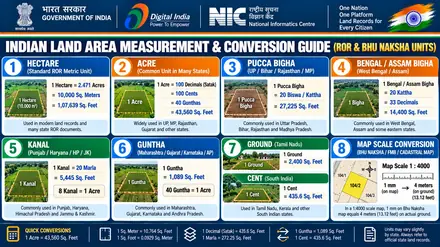
स्थानीय जमीन नापने की इकाइयां और बीघा-एकड़ फार्मूला (Local Land Measurement Units & Formulas)
Land records in Kerala (കേരളം) on Ente Bhoomi, E-Rekha & Revenue E-Services record plot areas using local units alongside metric hectares. Use this conversion table to calculate your exact land area in square feet, square meters, and acres:
| Regional Measurement Unit | Square Feet Equivalent | Metric Equivalent | Mathematical Formula & Ground Context |
|---|---|---|---|
| 1 Acre (Standard) | 43,560 sq ft | 4,046.86 sq meters | Standard Indian land measurement unit used across commercial transactions. |
| 1 Hectare (Metric) | 1,07,639 sq ft | 10,000.00 sq meters | Official unit used on computerized Ente Bhoomi, E-Rekha & Revenue E-Services records. Equal to 2.471 Acres. |
| 1 Cent / Decimal | 435.6 sq ft | 40.46 sq meters | 1/100th of an Acre. Common fractional parcel measurement. |
| 1 Square Yard (Gaj) | 9.00 sq ft | 0.8361 sq meters | Standard urban residential plot layout measure. |
| 1 Square Meter | 10.764 sq ft | 1.00 sq meter | Standard SI unit for building plinth and municipal demarcations. |
Tip: Use the interactive Citizen Land Utility Suite above to calculate custom plot dimensions, convert fractional shares, or verify boundaries before registration.
Check your Kerala land records in four steps
Follow these four steps to search and download your land records:
- Step 1: Open the official portal Ente Bhoomi, E-Rekha & Revenue E-Services (erekha.kerala.gov.in).
- Step 2: Select your District → Taluk → Village → Block Number from the location menus.
- Step 3: Enter your Resurvey Number & Block Number (or Old Survey Number), Thandaper Number, or recorded owner name.
- Step 4: View your Thandaper Account & Patta (Pattayam) and download the FMB Sketch (Field Measurement Book) & Resurvey Map PDF map.
Official Kerala revenue portal summary
| Attribute | Official Kerala Details |
|---|---|
| State or Union Territory | Kerala • കേരളം (South India) |
| Official Languages | മലയാളം (Malayalam) and English |
| Official Portal Name | Ente Bhoomi, E-Rekha & Revenue E-Services (ഇ-രേഖ & റവന്യൂ ഇ-സർവീസസ് (E-Rekha & Kerala Revenue)) |
| Verified Gov Portal Domain | erekha.kerala.gov.in • Open Direct Gov Gateway ↗ |
| Managing Authority | Department of Survey and Land Records & Land Revenue Commissionerate, Kerala |
| Ownership Document (ROR) | Thandaper Account & Patta (Pattayam) |
| Cadastral Plot Map | FMB Sketch (Field Measurement Book) & Resurvey Map |
| Plot or Survey Identifier | Resurvey Number & Block Number (or Old Survey Number) |
| Account or Ledger Identifier | Thandaper Number |
| Mutation Process | Pokkuvaravu (Transfer of Registry / Mutation) |
| Citizen Inspection & Copy Fees | Free Public Viewing (₹0) • Certified Copy: As per Kerala DSLR & Revenue Fee Schedule |
| Statutory Service Delivery (RTPS) | Notified under Kerala State Right to Service Act, 2012: 15 to 30 working days for undisputed transfer of registry (Pokkuvaravu); certified Thandaper extract within 7 days (Village Officer / Tahsildar). |
| Bhu-Aadhaar (ULPIN) Standard | ULPIN is being implemented through the national land-records modernisation programme. Availability varies by state, district, village and parcel. Check the official DILRMP status information or the relevant state revenue portal before assuming that a parcel has an assigned ULPIN. |
| Governing Statutory Land Act | Kerala Land Revenue & Tenancy Regulations (administered by Department of Survey and Land Records & Land Revenue Commissionerate, Kerala) |
| Administrative Hierarchy | District → Taluk → Village → Block Number |
Official government land portals for Kerala
All links below connect directly to authentic state and central revenue servers. Server availability is monitored regularly.
Official state revenue servers experience heavy traffic between 11:00 AM and 04:00 PM due to Tehsil Sub-Registrar transactions, which may cause CAPTCHA timeouts.
| Portal Name | Primary Service | Domain & Status | Direct Access Link |
|---|---|---|---|
| E-Rekha Kerala (Survey Maps & FMB) | FMB Sketch, Village Maps & Settlement Register | ✔ Official Portal Link erekha.kerala.gov.in | Open Portal ↗ |
| Kerala Revenue E-Services | Land Tax, Thandaper & Possession Certificate | ✔ Official Portal Link revenue.kerala.gov.in | Open Portal ↗ |
Genuine revenue records in Kerala are accessible exclusively through authorized government portals ending with .gov.in or .nic.in. Beware of commercial websites asking for monthly subscriptions, debit card numbers, or mobile OTPs. Official uncertified record viewing is free of cost across all districts.
जमीन का रिकॉर्ड खोजने से पहले आवश्यक जानकारी (Details Required Before Searching Land Records)
Keep these details ready before searching on Ente Bhoomi, E-Rekha & Revenue E-Services:
- Location path: Select your District → Taluk → Village → Block Number from the dropdown menus.
- Resurvey Number & Block Number (or Old Survey Number): Locates your parcel on the village map and shows boundary dimensions.
- Thandaper Number: Displays all plots registered under a single family or owner.
- Landowner name: Use this search option if you do not know the plot or account number.
What to do if your Kerala land record is not found online
While the majority of revenue villages in Kerala are digitized under the Digital India Land Records Modernization Programme (DILRMP), certain records may not appear in the online search. This typically happens in rural consolidation (chakkbandi) areas, newly bifurcated tehsils, parcels under ongoing consolidation court proceedings, or forest fringe zones.
Visit your jurisdictional Tehsil, Taluk, or Anchal revenue counter with your village name, Khasra or Khatauni reference, and owner name.
Submit an application for a certified manual copy of the Thandaper Account extract or survey sketch from the Village Office or Taluk Revenue Record Section. Fees are payable as per the Kerala DSLR and revenue fee schedule with an official receipt.
If your village map sheet does not show parcel lines, submit a demarcation request (*Paimaish* / *Mojani*) through the Revenue Inspector or government surveyor (*Amin* / *Patwari*).
Village-level Common Service Centers (CSC) can verify if your record was recently locked during annual Jamabandi revision or pending mutation entry.
खेत / प्लॉट का भू-नक्शा (शजरा मैप) ऑनलाइन कैसे देखें और डाउनलोड करें? (How to View & Download Plot Map)
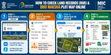
The cadastral map shows parcel boundaries, dimensions, and neighboring plots. Follow these five steps:
- Open the official Kerala mapping portal (Kerala Revenue E-Services).
- Select your District → Taluk → Village → Block Number in the location menu to load the village map sheet.
- Enter your Resurvey Number & Block Number (or Old Survey Number) in the search box, or click directly on the land parcel inside the village map.
- Review the owner names, plot area, and land classification displayed in the verification panel.
- Click Map Report or Sketch PDF to save the plot map with its scale and north arrow.
erekha.kerala.gov.in. भू-नक्शे पर खेत की सीमाएं, रास्ता और सरकारी संकेत कैसे समझें? (Understanding Plot Boundaries & Map Symbols)
Official village cadastral sheets (FMB Sketch (Field Measurement Book) & Resurvey Map) use standardized cartographic symbols. Use this decoder to identify access roads, canals, and plot boundaries:
When reviewing plot numbers on the FMB Sketch (Field Measurement Book) & Resurvey Map, note the distinction between sub-divided and undivided parcels:
• Bata Khasra (e.g. 142/1, 142/2): Indicates an officially surveyed sub-division with defined boundary lines plotted on the cadastral map.
• Minjumla Khasra (e.g. 142 Min): Indicates an undivided co-share where the owner's legal fraction is recorded in the ledger, but specific boundary lines have not yet been demarcated on the physical map sheet.
If you are purchasing a Minjumla parcel, insist on an official boundary demarcation (Haddbandi / Seemankan under Kerala Land Revenue & Tenancy Regulations (administered by Department of Survey and Land Records & Land Revenue Commissionerate, Kerala)) before signing the final sale deed to ensure undisputed physical possession.
ऑनलाइन खसरा-खतौनी (जमीन का रिकॉर्ड) निकालने की पूरी प्रक्रिया (How to Check Land Ownership Record Online)
The Thandaper Account & Patta (Pattayam) confirms ownership, share extent, and bank mortgage remarks. Follow these steps:
- Open E-Rekha Kerala (Survey Maps & FMB) (erekha.kerala.gov.in) in your web browser.
- Select the option to view Thandaper Account & Patta (Pattayam) on the home screen.
- Choose your District → Taluk → Village → Block Number and the current revenue year.
- Select your search method (Resurvey Number & Block Number (or Old Survey Number), Thandaper Number, or Owner Name), enter the value, and submit the captcha code.
- Check each co-owner's share, total land area, and the remarks column, then print or save the PDF copy.
If you do not have your Resurvey Number & Block Number (or Old Survey Number) or Thandaper Number, follow these simple steps:
1. Select your District → Taluk → Village → Block Number as usual.
2. Click the search tab labeled खातेदार के नाम द्वारा खोजें (Search by Landholder Name).
3. Type the first 1 to 2 letters of the recorded owner name using the on-screen phonetic keyboard.
4. Select the matching name from the citizen list to reveal all registered Resurvey Number & Block Number (or Old Survey Number) numbers, total landholding area, and co-sharer details.
खतौनी / जमाबंदी में इन जरूरी जानकारियों की जांच अवश्य करें (Key Details to Verify on Your Land Record)
Official revenue extracts on Ente Bhoomi, E-Rekha & Revenue E-Services use five standard columns. Use this table to verify each section before buying land or applying for a loan:
| Document Column | Meaning in Kerala | Buyer Verification Action |
|---|---|---|
| 1. Thandaper Number | Unique ledger number assigned to a landowner or joint family holding in the village. | Match the seller's name and parent or spouse name with their Aadhaar card and sale deed. |
| 2. Resurvey Number & Block Number (or Old Survey Number) | Unique parcel number on the village cadastral map (FMB Sketch (Field Measurement Book) & Resurvey Map). | Confirm that the plot number on the Thandaper Account & Patta (Pattayam) matches the parcel on the FMB Sketch (Field Measurement Book) & Resurvey Map. |
| 3. Land Area and Share | Total parcel area and each co-owner's fractional share. | Verify that the sale area stays within the seller's recorded share using the Area Unit Calculator. |
| 4. Land Classification | Category of land: Purayidam (Dry/Garden/Residential Land), Nilam (Paddy/Wetland), Pandaravaka, Jenmom, and Puramboke (Government).. | Confirm that the parcel belongs to a private transferable land category. |
| 5. Remarks and Mutation | Lists Pokkuvaravu (Transfer of Registry / Mutation) orders, crop loans (KCC), bank mortgages, and court orders. | Confirm that the remarks column shows a clear title for the parcel. |
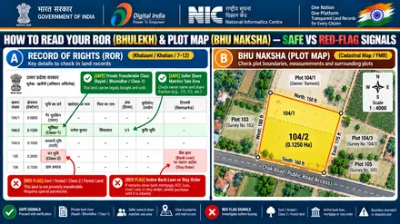
Before paying any advance for land in Kerala, carefully inspect the Remarks Column (विवरण / अन्य विवरण). Look for entries stating "बंधक" (Mortgage), bank loan liens, or court stay orders (न्यायालय स्थगनादेश). If an outstanding registered mortgage or bank lien is recorded, a Bank No-Objection Certificate (NOC) alone is insufficient to clear title. A formal Deed of Reconveyance or Release of Mortgage must be executed by the lending institution and registered at the competent Sub-Registrar Office (SRO) under the Registration Act, 1908. Following registration, an application must be filed before the local revenue office (such as the Tehsil, Taluk Office, or BL&LRO) with the registered release deed to formally discharge the bank's charge or lien entry from the Record of Rights.
While the Thandaper Account serves as the official fiscal revenue ledger for Basic Tax collection, the Basic Tax Register (BTR) and Field Measurement Book (FMB) reflect surveyed boundaries and revenue classifications. The Supreme Court has established that revenue entries and Pokkuvaravu (mutation) do not confer or extinguish legal ownership title (Bhimabai Mahadeo Kambekar v. Arthur Import & Export Co. (2019) 3 SCC 191). Legal ownership must be verified through registered title deeds, Encumbrance Certificates from the Sub-Registrar Office, and physical possession.
भू-आधार (ULPIN): 14-अंकीय विशिष्ट भू-खंड पहचान संख्या (14-Digit Land Parcel Identifier)
Under the Digital India Land Records Modernization Programme (DILRMP), revenue authorities in Kerala (കേരളം) are linking agricultural and non-agricultural plots with Bhu-Aadhaar (also known as ULPIN: Unique Land Parcel Identification Number).
Just as a 12-digit Aadhaar uniquely identifies an Indian citizen, a 14-character alphanumeric Bhu-Aadhaar uniquely identifies a specific piece of geographic land on earth. It is generated from the exact GPS latitude and longitude of the plot corners based on international ISO 19152 Land Administration Domain Model (LADM) standards.
| ULPIN Code Segment | Standard Administrative Level | Role in Land Registry & Verification |
|---|---|---|
| Characters 1 and 2 | State Census Code (32) | Specifies the state jurisdiction (Kerala prefix: 32). |
| Characters 3 and 4 | District Census Code | Identifies the revenue district authority. |
| Characters 5, 6, and 7 | Sub-District / Tehsil Code | Identifies the local Tehsil, Taluka, or Anchal office. |
| Characters 8, 9, and 10 | Revenue Village / Mauza Code | Locates the village survey map where the Resurvey Number & Block Number is situated. |
| Characters 11 to 14 | GIS Centroid Coordinate Hash | Unique spatial coordinates calculated from the parcel boundary polygon. |
Type or paste your 14-character Bhu-Aadhaar code from your computer-generated Thandaper Account & Patta to verify its structure:
Provides a single 14-character alphanumeric reference standard based on parcel boundary vertices coordinates under the ISO 19152 Land Administration Domain Model.
Serves as a common identifier across revenue, survey, and registration departments to reduce cadastral ambiguity in participating states.
Enables linking of textual Record of Rights (RoR) data directly with computerized GIS village maps (Bhu Naksha) where surveys are finalized.
Printed in the header of computerized land records and visible on the official state cadastral map portal for surveyed villages.
सरकारी शुल्क, नकल मिलने की समय-सीमा और कानूनी मान्यता (Official Fees, Timeline & Legal Validity)
Review the fee structure, processing time, and legal use case for each Kerala revenue document:
| Service Type | Official Fee | Processing Time | Legal Validity and Use Case |
|---|---|---|---|
| Informational Thandaper Account & Patta (Pattayam) View | Free (₹0) | Instant Online | Personal verification of owner name, share, and plot status. |
| Informational FMB Sketch (Field Measurement Book) & Resurvey Map PDF | Free (₹0) | Instant Online | Checking plot boundaries, road access, and neighboring survey numbers. |
| Digitally Signed QR Thandaper Account & Patta (Pattayam) or Map | ₹15 to ₹50 per copy | Instant to 24 Hours | Admissible for statutory verification, bank loans, and official transactions when verified against state QR servers. Users can preview FMB sketches and old settlement registers on E-Rekha and pay online to download certified copies, or pay Basic Land Tax via revenue.kerala.gov.in. |
| Pokkuvaravu (Transfer of Registry / Mutation) Application | Standard State Tariff | State RTPS Notified Limits (Case Dependent) | Updates the buyer or legal heir name in the Thandaper Account & Patta (Pattayam) after deed registration or succession. |
जमीन खरीदने से पहले जरूरी कानूनी जांच एवं विवाद निवारण प्रक्रिया (Property Buyer Verification & Dispute Appeals)
Land administration and records of rights in Kerala (കേരളം) follow the Kerala Land Revenue & Tenancy Regulations (administered by Department of Survey and Land Records & Land Revenue Commissionerate, Kerala). Before buying land or settling a boundary dispute, complete these seven due diligence checks:
Seven property checks before buying land in Kerala
| Due Diligence Step | What to Verify on Ente Bhoomi, E-Rekha & Revenue E-Services | Critical Legal Risk / Red Flag |
|---|---|---|
| 1. Title & Fractional Share Match | Cross-verify the seller's name, parent/spouse name, and exact fraction in the Thandaper Account & Patta register against the Sub-Registrar registered deed. | Red Flag: Discrepancy between the registered Sale Deed and the live computerized Thandaper Account & Patta. Never purchase property based solely on an unverified power of attorney (GPA). |
| 2. Electronic Evidence Admissibility (Section 63 BSA 2023) | Download a Digitally Signed QR Copy from Ente Bhoomi, E-Rekha & Revenue E-Services or obtain a certified copy from the respective Tehsil / Revenue office. | Red Flag: Uncertified portal printouts serve for informational reference only. For judicial proceedings, bank mortgages, or statutory registrations, obtain an officially certified extract or digitally signed copy bearing QR validation as governed by Sections 63 and 74-76 of Bharatiya Sakshya Adhiniyam, 2023. |
| 3. Encumbrance & Bank Liens | Inspect Remarks Column 7/8/9 of the Thandaper Account & Patta and verify 12 to 30 year Encumbrance Certificates (EC) on the state registration portal. | Red Flag: Undisclosed Kisan Credit Card (KCC) agricultural loans, cooperative bank hypothecations, or commercial bank mortgage charges. |
| 4. Pending Litigation & Stay Orders | Check if the Resurvey Number & Block Number (or Old Survey Number) has pending succession (Varasat) disputes, partition suits, or revenue court injunction orders. | Red Flag: Buying land subject to pending litigation under Kerala Land Revenue & Tenancy Regulations (administered by Department of Survey and Land Records & Land Revenue Commissionerate, Kerala). Transfer during litigation is subject to Section 52 Transfer of Property Act (Lis Pendens). |
| 5. Restricted & Non-Alienable Land | Verify the land class code (e.g. Government Vested, Ceiling Surplus, Gram Sabha, Bhoodan, Waqf, or SC/ST Tribal Protective Tenancy). | Red Flag: Sale of assigned, tribal, or ceiling surplus land without prior statutory permission from the District Collector is null and void ab initio. |
| 6. Land Use & NA Conversion Order | If buying for residential or commercial construction, verify the formal Non-Agricultural (NA / Diversion / Bastu / CLU) order number. | Red Flag: Constructing on unconverted agricultural land risks demolition and heavy penalties under state town planning and revenue codes. |
| 7. Ground Chauhaddi & Cadastral Naksha Match | Measure the parcel physically and match all 4 boundaries (North, South, East, West) with the scaled village map (`1:4000`). | Red Flag: Encroachment by neighboring plots or mismatch between physical ground boundaries and the digitized cadastral sheet. |
Official revenue appeal hierarchy in Kerala
If you find a spelling error in your Thandaper Account & Patta, face boundary encroachment, or experience delays in Pokkuvaravu, follow this administrative appeal hierarchy:
| Administrative Tier | Designated Revenue Authority | Statutory Role & Citizen Recourse |
|---|---|---|
| Tier 1: Village Level | Village Officer (VO) | Performs ground boundary verification, inspects physical possession, and verifies the Resurvey Number & Block Number (or Old Survey Number). |
| Tier 2: Circle Level | Revenue Inspector / Kanungo | Conducts dispute verification and submits field recommendations regarding Thandaper Account & Patta records. |
| Tier 3: Tehsil / Taluk | Tehsildar / Circle Officer / Mamlatdar | Passes formal Pokkuvaravu orders, adjudicates ownership disputes, and approves certified extracts. |
| Tier 4: Sub-Division | Sub-Divisional Officer (SDO) / Sub-Collector | First statutory appellate authority for mutation and record correction challenges. |
| Tier 5: District Level | District Collector / Deputy Commissioner | Supervises district land administration, government land protection, and revision appeals. |
| Tier 6: State Apex | Board of Revenue / Financial Commissioner (Kerala) | Apex state revenue tribunal adjudicating final revisions and title references. |
Statutory Service Timeline: Notified under Kerala State Right to Service Act, 2012: 15 to 30 working days for undisputed transfer of registry (Pokkuvaravu); certified Thandaper extract within 7 days (Village Officer / Tahsildar). • Bhu-Aadhaar Status: ULPIN is being implemented through the national land-records modernisation programme. Availability varies by state, district, village and parcel. Check the official DILRMP status information or the relevant state revenue portal before assuming that a parcel has an assigned ULPIN.
दाखिल-खारिज (नामांतरण) केस की स्थिति ऑनलाइन कैसे चेक करें? (Check Mutation Status Online)
After executing a registered sale deed, gift deed, or succession filing in Kerala (കേരളം), completing Pokkuvaravu is mandatory to substitute the seller or deceased owner's name with your name in the official Thandaper Account & Patta. Follow this tracking guide on E-Rekha Kerala (Survey Maps & FMB):
1. By Revenue Court Case Number (वाद संख्या): Enter the official computerized case number generated during application filing.
2. By Registered Deed Number (दस्तावेज संख्या): Enter the Sub-Registrar deed number, volume, and registration year from your sale deed.
3. By Applicant or Party Name: Search by buyer name or seller name with father/husband name in Devanagari or English.
4. By Resurvey Number & Block Number / Mauza: Select your District → Taluk → Village and enter your plot number to see all pending or disposed mutation cases.
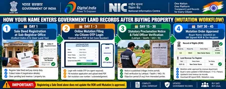
Statutory mutation approval stages in Kerala
| Mutation Stage | Statutory Procedure & Officer Action | What Citizen Must Verify |
|---|---|---|
| 1. Application Submission & Filing Acknowledgment | Application submitted online on the official Kerala revenue portal (Ente Bhoomi, E-Rekha & Revenue E-Services) or at the local Tehsil / Sub-Divisional counter, generating a computerized Case / Application Number. | Secure the computerized filing receipt and record the official application tracking number. |
| 2. Statutory Public Notice & Objections | Public notice is issued inviting objections in accordance with statutory procedures under applicable State Land Revenue Act and Rules. The notice period allows recorded right-holders to submit valid claims. | Check the specific notice expiration date indicated on your case acknowledgment receipt. Undisputed cases proceed for field verification. |
| 3. Field Verification & Possession Report | The designated local revenue officer (Village Revenue Officer, Revenue Inspector, or Patwari) visits the ground to verify peaceful physical possession and boundary compliance. | Confirm that the field verification report has been endorsed and submitted to the competent revenue authority without adverse remarks. |
| 4. Hearing & Competent Authority Order | The designated Revenue Officer (Tahsildar, Circle Officer, or Sub-Divisional Magistrate) reviews statutory verification reports, examines deed validity, and passes the formal mutation order. | Download or obtain a certified copy of the signed disposal order. Confirm that plot extent and buyer details are accurately sanctioned. |
| 5. Computerized Record of Rights (RoR) Update | The computerized revenue cell executes the order, formally updating the official Thandaper Account & Patta (Pattayam) ledger and issuing the updated ownership extract. | Download a fresh copy of your computerized Thandaper Account & Patta (Pattayam) from Ente Bhoomi, E-Rekha & Revenue E-Services to verify that your ownership title is officially recorded. |
If a co-sharer or third party files an objection during the notice period, the case converts from an undisputed summary proceeding into a regular contested revenue lawsuit (विवादित वाद). Both parties are summoned with notices. As the buyer, you must present the certified copy of your registered sale deed, proof of physical possession (Chauhaddi), and modern computerized Thandaper Account & Patta extracts. Under Kerala Land Revenue & Tenancy Regulations (administered by Department of Survey and Land Records & Land Revenue Commissionerate, Kerala), summary revenue proceedings cannot determine complex civil title questions, which belong exclusively to the Civil Court.
If your registered property deed dates back several decades, the plot number recorded on the deed may refer to older Cadastral Survey (CS), Revisional Survey (RS), or pre-consolidation (Chakbandi) settlement registers. To find your modern Resurvey Number & Block Number:
1. Check the Chauhaddi (चारदीवारी / Four Boundaries) on your registered deed to identify fixed physical benchmarks (neighboring roads, canals, or ancestral plots).
2. Open the village cadastral map (FMB Sketch (Field Measurement Book) & Resurvey Map) on Ente Bhoomi, E-Rekha & Revenue E-Services and visually locate the plot shape using neighboring benchmark numbers.
3. If the survey numbers changed during re-settlement, request a Comparative Table (मिलान तालिका / Charkatta) from the District Collectorate Record Room (मुहाफ़िज़खाना) to bridge old survey numbers with current computerized records.
Troubleshooting search and portal errors in Kerala
If the government portal returns blank results or an error, check these database entry rules:
Record not found after recent registration
A recently registered transaction may not appear in the online Record of Rights until the mutation process has been completed and the record updated. Processing and update times vary by state, service category, and case circumstances. Use the official application-status facility or contact the competent revenue office for the status of your case.
Suffix Split Format
Southern state portals separate base survey numbers from sub-division codes. Enter base number 124 in the main field and sub-division 2A in the Hissa or sub-division box to avoid search timeouts.
Name search returns zero results
State revenue databases store owner names in the regional script. Searching in English letters returns blank results. Enter the name using the script tool below or search by plot number.
Map shows a blank white page
Cadastral map engines open plot reports in a separate window. Allow pop-ups in your browser settings for https://revenue.kerala.gov.in.
Document check: Remarks and encumbrance verification
Inspect the liabilities and remarks column of the Thandaper Account & Patta. Unresolved bank charges, ceiling reservations, or court disputes recorded here must be cleared before completing a purchase.
Post-search action scripts and application drafts for Kerala
If you discovered a misspelled name, missing plot share, or boundary conflict while inspecting your Kerala land records, copy these ready-to-use application templates to submit to the revenue authority:
1. Application for correction of clerical error in digital Thandaper Account & Patta
To,
The Tehsildar / Talukdar / Circle Officer,
Revenue Circle / Tehsil: ______________________,
District: ______________________, State: Kerala Subject: Application for correction of clerical / typographical error in Digital Thandaper Account & Patta. Respected Sir/Madam, I, _______________________________, S/o / D/o / W/o _______________________________,
resident of Village: __________________________, Tehsil: __________________________,
District: __________________________, state as follows: 1. I am the lawful recorded owner of land located in: - Village / Mouza: __________________________ - Khata / Account Number: ___________________ - Resurvey Number & Block Number: ________________ - Total Area: _______________________________ 2. Upon inspecting the computerized record on Ente Bhoomi, E-Rekha & Revenue E-Services, I observed the following error: - Existing Recorded Detail on Portal: __________________________________________________ - Correct Detail as per Registered Title Deed: _________________________________________ 3. Enclosed herewith are attested copies of: a) Registered Sale Deed / Partition Deed No. ____________ dated ____________ b) Current Land Revenue Tax Receipt c) Identity Proof (Aadhaar Card) I request your office to order the necessary field verification and direct the Patwari / Revenue Inspector to correct the digital record accordingly. Date: ____ / ____ / 202__
Place: ____________________
Signature: ______________________________
Mobile Number: __________________________
2. Formal request for physical field demarcation (FMB Sketch survey)
To,
The Assistant Director of Land Records (ADLR) / Tehsildar,
Department of Revenue & Land Records,
District: ______________________, State: Kerala Subject: Request for physical field demarcation and boundary measurement based on official FMB Sketch. Respected Sir/Madam, I, _______________________________, am the lawful owner in physical possession of:
- Resurvey Number & Block Number: ________________________
- Village / Mouza: ____________________________________
- Tehsil / Taluk: _____________________________________
- District: ___________________________________________ Due to missing boundary stones / border disputes along adjacent parcels, I request an official field inspection and physical demarcation using the cadastral plot map layout. I have deposited the requisite official measurement fee of ₹__________ (Challan / Receipt enclosed). Please issue notice to the adjacent landholders and schedule the measurement date. Date: ____ / ____ / 202__
Place: ____________________
Signature: ______________________________
Contact: ________________________________
भूमि के प्रकार (कृषि, गैर-कृषि, आबादी) एवं हेल्पलाइन नंबर (Land Types & Official Helplines)
Land classifications in Kerala: Purayidam (Dry/Garden/Residential Land), Nilam (Paddy/Wetland), Pandaravaka, Jenmom, and Puramboke (Government)..
Certified copy procedure: Users can preview FMB sketches and old settlement registers on E-Rekha and pay online to download certified copies, or pay Basic Land Tax via revenue.kerala.gov.in.
Helpdesk and office support: Village Office / Akshaya e-Center Kerala.
Under the Kerala Land Revenue & Tenancy Regulations (administered by Department of Survey and Land Records & Land Revenue Commissionerate, Kerala) and State Public Services Guarantee Act, undisputed mutation (Pokkuvaravu) and certified Thandaper Account & Patta copies follow the notified statutory timeframe: Notified under Kerala State Right to Service Act, 2012: 15 to 30 working days for undisputed transfer of registry (Pokkuvaravu); certified Thandaper extract within 7 days (Village Officer / Tahsildar). If your application faces unexplained administrative delays or demands for unlawful gratification:
• First Appeal: File a statutory revision before the Sub-Divisional Officer (SDO / SDM) of your sub-division.
• Second Appeal: Escalate to the Additional District Magistrate (ADM / Revenue) or District Collector.
• Online Grievance Redressal: Submit a formal tracking complaint on the official state Chief Minister grievance redressal portal (e.g. CM Helpline / Lok Shikayat / Sampark / Jansunwai).
Citizen login and online land tax payment in Kerala
Use these five official citizen service modules on Ente Bhoomi, E-Rekha & Revenue E-Services (erekha.kerala.gov.in) to log in, check plot and Thandaper Account & Patta details by owner name, pay land revenue tax online, and link Aadhaar:
| Portal Module / Service | How It Works on Ente Bhoomi, E-Rekha & Revenue E-Services (KL) | Exact Menu Path & Citizen Action |
|---|---|---|
| 1. Free Thandaper Account & Patta & Plot Info No Login Needed | Displays live plot area, land classification, co-sharer fractions, and Pokkuvaravu (Transfer of Registry / Mutation) history by Resurvey Number & Block Number (or Old Survey Number), Thandaper Number, or Owner Name. | Verify Land Details / Public View > Select District, Taluk, Village, Block & Re-Survey Number on official Kerala Thandaper Account & Patta portal (erekha.kerala.gov.in) ↗. |
| 2. Cadastral Plot Map (FMB Sketch) Direct Map Sheet | Shows the scaled village map (`1:4000`), 4-side boundary lengths, road access, and neighboring plot numbers (Chauhaddi). | File Search > FMB / Resurvey Sketch / Correlation Statement > Select District, Taluk & Village on official Kerala FMB Sketch portal (erekha.kerala.gov.in) ↗. |
| 3. Citizen Login, Tax & Pokkuvaravu Mobile OTP Login | Pays annual land revenue tax (Khajna / Lagan / Pauti), downloads digitally signed QR copies (₹15 to ₹50), and tracks Pokkuvaravu (Transfer of Registry / Mutation). | Citizen Login (Mobile/Email + OTP) > Pay Land Tax Online & Download QR Tax Receipt on official Kerala Citizen Login (erekha.kerala.gov.in) ↗. |
| 4. Sub-Registrar Deed & EC Check IGRS / Stamp Portal | Verifies registered Sale Deeds (Index-II), 12 to 30 year Encumbrance Certificates (EC), government circle rates, and prohibited land lists. | Citizen Services > View Fair Value of Land & Apply/Verify Encumbrance Certificate (EC) on official Kerala IGRS portal (keralaregistration.gov.in) ↗. |
5. Aadhaar e-KYC & Record CorrectionGrievance & Correction | Links the landowner's Aadhaar and mobile number with their Thandaper Number to prevent fraudulent transfers and correct clerical spelling or area errors. | Submit an online correction request with your registered deed PDF or apply to your local revenue officer (Village Office). |
Step-by-step land revenue tax payment and digital receipt (e-Pauti) download
Paying annual land revenue tax (Lagan / Khajna / e-Pauti / Bhu-Rajaswa) online maintains fiscal compliance with state revenue authorities. Payment of land tax is for revenue collection purposes and does not establish ownership title, prove adverse possession, or resolve competing property claims. Follow these steps on Ente Bhoomi, E-Rekha & Revenue E-Services:
- Step 1 (Select Location): Open the official tax payment module and select your District → Taluk → Village → Block Number.
- Step 2 (Locate Demand Ledger): Enter your Thandaper Number or Resurvey Number & Block Number (or Old Survey Number) to view the computerized demand register (Register-II / Jamabandi).
- Step 3 (Inspect Arrears): Review the fee demand calculation, past payment history, cess, and any penalty interest. Confirm that no prior financial year arrears remain pending.
- Step 4 (Online Payment): Pay the assessed tax securely via the State Cyber Treasury gateway using UPI, Net Banking, or Debit Card.
- Step 5 (Download QR e-Pauti): Instantly download and print the digitally signed tax clearance receipt (e-Pauti) containing the Government Reference Number (GRN) and payment verification barcode.
Check Kerala E-Rekha survey maps and Thandaper online
Use these official services to verify ownership, inspect plot maps, check encumbrances, and track mutation orders in Kerala:
| Kerala Service Module | Key Features & User Benefit | Exact Link & Action Steps |
|---|---|---|
| 1. e-Rekha Survey & Resurvey Map Search | Search digitized cadastral survey and resurvey maps by District, Taluk, Village, and Block / Survey Number without login. | Open Kerala e-Rekha Portal ↗, select File Search, choose location, and view the high-resolution survey map. |
| 2. Ente Bhoomi & Revenue e-Services (Land Tax) | Pay annual basic land tax online, check Thandaper Account ledgers, and download instant electronic tax receipts (Pothi). | Log in to Kerala Revenue Portal ↗ with your mobile OTP to pay land tax and download receipts. |
| 3. FMB & Location Sketch | Inspects scaled Field Measurement Book (FMB) sketches and location sketches prepared by the Village Officer / Taluk Surveyor. | Download FMB sheets from e-Rekha or apply through your Village Office for official location sketches. |
| 4. Pokkuvaravu (Mutation Tracking) | Monitors mutation applications filed after registered sale deeds or inheritance before the Village Officer and Tahsildar. | Track your Pokkuvaravu petition online on the Revenue portal to ensure Thandaper ownership has been updated. |
| 5. Kerala Paddy Land and Wetland Act 2008 (Nilam vs Purayidam) | Strict legal prohibition against unauthorized construction or landfill on paddy lands (Nilam). Only land classified as garden land (Purayidam) is buildable. | Check the Basic Tax Register (BTR) classification and verify formal RDO data bank conversion orders before buying land. |
Land classifications and transfer rules in Kerala
Before paying an advance or registering a Sale Deed in Kerala (കേരളം), check the land classification code on the Thandaper Account & Patta against this legal verification table:
| Verification Check | Official Kerala Revenue Code & Legal Meaning | What a Buyer or Owner Must Do |
|---|---|---|
| 1. Safe Transferable Land Class | Purayidam (പുരയിടം: Dry/Garden Transferable Land with Active Thandaper & Clear Tax Receipt) | Confirm that the seller's name, parent/spouse name, and fractional share match both the Thandaper Account & Patta and the Sub-Registrar EC. |
| 2. Restricted / Prohibited Land Class (Red Flag) | Nilam (നിലം: Paddy/Wetland Protected under Kerala Conservation of Paddy Land & Wetland Act 2008), Puramboke | Do not pay an advance. Government, Vested, Forest, or Class-2/Assigned land cannot be sold without prior statutory Collector permission. |
| 3. Non-Agricultural (NA / Conversion) Check | Agricultural plots require formal land-use conversion (NA / Bastu / CLU / Diversion) before residential or commercial construction. | Verify the official Conversion Order number on the Thandaper Account & Patta before buying a plotted layout or house site. |
| 4. Un-Subdivided Joint Plot (Min / Bataank / Phodi) | When a plot is sold from a larger joint parcel, the new sub-division (`/1`, `/2`, `Min`) must be drawn on the FMB Sketch. | Insist on an official pre-mutation sketch or boundary demarcation so your exact ground parcel is separated on the village map. |
| 5. Revenue Officer Escalation & Helpdesk | Official Authority: Department of Survey and Land Records & Land Revenue Commissionerate, Kerala Support & Escalation: Village Office / Akshaya e-Center Kerala | File clerical corrections or delayed Pokkuvaravu appeals online with your Case Number and registered deed copy. |
District coverage for Kerala land records
Official Ente Bhoomi, E-Rekha & Revenue E-Services land records, Thandaper Account & Patta registers, and cadastral village maps cover all revenue districts and local revenue offices across Kerala:
Local revenue terms in Kerala
Use these regional definitions to read Kerala revenue documents accurately (see also the All-India Land Terminology Glossary):
Thandaper Account
Unique landholder account number in a village under which all survey parcels owned by an individual are grouped for Basic Tax payment.
Pokkuvaravu
Mutation process (Transfer of Registry) updating the Thandaper register after a property deed is registered.
FMB (Field Measurement Book)
Measured survey sketch of each field/resurvey plot stored on the E-Rekha portal.
Nilam & Purayidam
Primary land classification distinguishing wetland or paddy land (Nilam, protected under Kerala Conservation of Paddy Land and Wetland Act) from dry garden or residential land (Purayidam).
जमीन खरीदने से पहले जांच के 3 आसान चरण (3-Step Land Verification Guide)
Complete these three checks before paying an advance or signing an agreement in Kerala:
Seller identity and title match
Compare the seller name and parentage in the digital Thandaper Account & Patta directly against their government photo identity (Aadhaar, PAN) and registered deed.
Ground boundary and map match
Inspect the plot on site with the official FMB Sketch. Confirm that road access, boundary dimensions, and neighboring plot numbers match the surveyed sheet.
Mutation status tracking
Deed registration at the Sub-Registrar office records the transfer, but revenue ownership updates only after mutation. Track the Pokkuvaravu until the new name is recorded on the ledger.
आधिकारिक Kerala राजस्व हेल्पलाइन एवं सहायता केंद्र (Official Helpdesk & Support)
यदि आपको Ente Bhoomi, E-Rekha & Revenue E-Services पोर्टल पर खतौनी देखने, भू-नक्शा डाउनलोड करने, या दाखिल-खारिज स्थिति ट्रैक करने में कोई तकनीकी बाधा आती है, तो आधिकारिक हेल्पलाइन से संपर्क करें:
📞 आधिकारिक संपर्क विवरण (Kerala Revenue Contact)
- हेल्पलाइन फोन: 0471-2320140
- वैकल्पिक सहायता: State Helpdesk: 0471-2325325
- ईमेल सहायता: director.survey@kerala.gov.in
- नियंत्रक विभाग: Department of Survey and Land Records, Government of Kerala
- मुख्यालय / पता: Survey Bhavan, Vazhuthacaud, Thiruvananthapuram, Kerala 695014
- कार्य दिवस व समय: 10:15 AM - 5:15 PM (Working Days)
- निकटतम केंद्र: Akshaya e-Center / Village Office
🛠️ आम तकनीकी समस्याओं के त्वरित समाधान
- सर्वर टाइमआउट (504 Gateway Timeout): सरकारी सर्वरों पर दोपहर 11 से 3 बजे के बीच ट्रैफिक अधिक होता है। सुबह 7 से 9 बजे अथवा शाम 6 बजे के बाद प्रयास करें।
- कैप्चा कोड (CAPTCHA) लोड न होना: ब्राउज़र का कैश साफ करें अथवा 'Private/Incognito Window' में वेबसाइट खोलें।
- नाम की स्पेलिंग न मिलना: सीधे नाम की जगह अपने Resurvey Number & Block Number से खोजें; इससे वही सटीक नाम प्रदर्शित होगा जो सरकारी रजिस्टर में दर्ज है।
- बैंक या कोर्ट के लिए प्रमाणित प्रति: ऑनलाइन कंप्यूटर प्रति केवल व्यक्तिगत जानकारी के लिए मान्य है। बैंक लोन अथवा कोर्ट पेशी हेतु अपने स्थानीय तहसीलदार कार्यालय या सीएससी केंद्र से डिजिटल हस्ताक्षर युक्त सर्टिफाइड कॉपी (Certified Copy) प्राप्त करें।
Frequently asked questions
Verified Citizen Queries1. [മലയാളം (Malayalam)] കേരളത്തിൽ FMB സ്കെച്ചും റീസർവ്വേ മാപ്പും ഓൺലൈനായി എവിടെ നിന്ന് ലഭിക്കും?
കേരള സർവ്വേ ആൻഡ് ലാൻഡ് റെക്കോർഡ്സ് വകുപ്പിന്റെ ഔദ്യോഗിക പോർട്ടലായ erekha.kerala.gov.in വഴി FMB സ്കെച്ചും വില്ലേജ് മാപ്പുകളും ലഭ്യമാണ്.
2. Which is the official website to check Kerala land records and plot maps?
The Department of Survey and Land Records & Land Revenue Commissionerate, Kerala manages the official Ente Bhoomi, E-Rekha & Revenue E-Services portal at official Ente Bhoomi, E-Rekha & Revenue E-Services website (erekha.kerala.gov.in).
3. What details are needed to view a plot map (FMB Sketch (Field Measurement Book) & Resurvey Map) in Kerala?
Select your location path (District, Taluk, Village, Block Number) and enter your Resurvey Number & Block Number (or Old Survey Number). You can also find the plot number by searching with the owner name in the Thandaper Account & Patta (Pattayam) register or clicking the parcel on the village map.
4. How do I get a legally valid copy from Ente Bhoomi, E-Rekha & Revenue E-Services for bank loans or court use?
Online printouts work for personal reference. For bank loans and court use, download a digitally signed copy with a QR code or get a certified extract from your local revenue office. Users can preview FMB sketches and old settlement registers on E-Rekha and pay online to download certified copies, or pay Basic Land Tax via revenue.kerala.gov.in.
5. How do I update my name in Kerala land records after buying land or inheritance?
Submit a Pokkuvaravu (Transfer of Registry / Mutation) application with your registered sale deed or succession certificate and identity proof on the state revenue portal or local Tehsil office. The revenue office updates the Thandaper Account & Patta (Pattayam) after approving the mutation order.
6. How does Bhu-Aadhaar (ULPIN) protect land buyers in Kerala?
Bhu-Aadhaar is a 14-character unique alphanumeric identifier assigned to land parcels based on the latitude and longitude coordinates of parcel boundary vertices. ULPIN serves as a standardized spatial identification code to identify and cross-verify land parcels on computerized cadastral maps; it does not independently guarantee legal title or prevent transactions without Sub-Registrar and revenue court verification. Active bank mortgages and encumbrance liens are recorded in your computerized Thandaper Account & Patta.
7. How do I pay land revenue tax (Lagan or Khajna) online in Kerala?
Access the tax module on Ente Bhoomi, E-Rekha & Revenue E-Services, enter your District and Taluk, check your demand register (Register-II or Jamabandi) for pending arrears, pay securely through the state cyber treasury gateway using UPI or Net Banking, and download your digitally signed e-Pauti tax receipt.